|
| The History Center on Main Street, 59 & 61 N. Main Street, Mansfield PA 16933 histcent83@gmail.com |
|
 |
|
Lower Daggett
Rufus Daggett, Sr.
Gristmill, Sawmill, and Tan Yard
Part I
Lower Daggett is a term you will not find on a map or hear used much today. It refers to the area between Eighmey's Bend and the Eighmey Road (T-789). It is in that area that tradition says the Daggetts first settled upon arriving here. The village of Daggett was not the first settlement site as some believe.
Eighmey's Bend refers to the path the old road took before the current road was constructed around 1957.1 As you travel north from the village of Daggett and reach the area where the gravel pit is now located, the old road ran along the base of the hill that the gravel pit excavated. There was a well or spring there along the old road that was covered up by the gravel operations. There are many local stories about it ranging from farmers storing milk to car radiators being refreshed.
As you reach the north end of the pit, the hill turned perpendicular to the hill of the gravel pit. The old road made a 90 degree turn to the left and followed the base of that hill to Seeley Creek. Then the road turned 90 degrees to the right and continued around the hill. That perpendicular hill made a natural barrier suitable for a mill pond to the south as the creek flowed in a northerly direction. That area to the south was where the mill pond was.
The old road to the east of SR 549 has pretty much disappeared, but the road to the west is still there. There are still remains of a mill dam that can be seen if you travel around the old road to the west.2
Around 1957 the perpendicular hill was cut through to make the current road. I am told that the gristmill was located on the north side of that hill in the path where the current road goes, and therefore, had to be removed. You can see why the road had to be changed. Those turns could not handle the traffic of today. It is a shame that the old gristmill had to be sacrificed.
It must have been quite a trip from Daggett. The mill pond would have been on your left as you went around it. The hill across the creek was high and steep, and during part of the year, you would have seen a waterfall to your left as you reached the mill dam. As you traversed the Bend, you would first see the gristmill and then the Big Elm.
On the north side of the perpendicular hill, there was a road that went up that hill and across its top where the cut is now that was used to reach property behind the current gravel pit. Parts of that road are still there.3
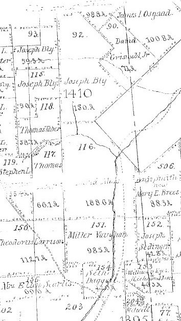
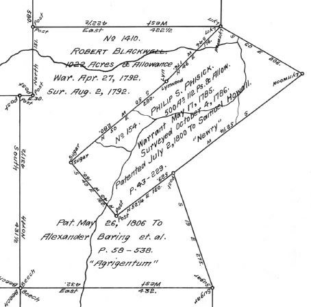
According to most accounts, the gristmill in Lower Daggett was the first
gristmill in Jackson Township. That area was originally part of a tract of land
designated as Lot 116 of the Bingham Lands of Jackson Township and was part of
Warrant 1410 called “Agrigentum.”
4
By deed dated May 17, 1810, the Trustees of the Bingham Estate sold Lot 116 to
David Moss for the sum of five shillings plus an amount as set forth in an
unrecorded agreement between the parties dated January of 1808.5
While the Bingham Map lists the acreage as 188.6 acres, the deed lists it as
190.4 acres. The deed also states that by the date of the agreement, David Moss
was “seated” thereon.
“Seated” is both a legal term and a term of art. “Unseated” lands were lands that were “privately owned but not cultivated, improved, or occupied.”6 An example of unseated lands would be the wild lands unsold by the Bingham Estate. Unseated land became seated land as soon as it was entered for purposes of development, occupation, or cultivation.7 The art comes in determining what is meant by cultivating, occupying, or improving. Being seated did not necessarily mean you lived on the property. The lands you see listed in the assessment books of the time are seated lands. Both terms are meaningless today. David Moss being “seated” on Lot 116 did not necessarily mean he was living there, but he most likely was.
By an instrument of even date with the deed, Mr. Moss gave the Bingham Trustees a mortgage secured by Lot 116 in the face amount of $235.60, and he received five shillings in cash for doing so.8
Between the deed and the mortgage, the five shillings were a wash transaction
and were what is referred to today as a validation device. Validation devices
are legal requirements needed to make deeds and contracts legally binding and
enforceable. Today, you will often see consideration in a deed listed as $1.00.
That $1.00 has the same legal effect as the five shillings as far as making the
transaction enforceable.
Because the agreement of January 1808 was not recorded and was just referred to
in general terms by the deed, we do not know if the $235.60 was the full
purchase price of the property. If it was, the lot was sold for
approximately $1.24 an acre.
The mortgage was payable in four yearly installments due on the first day of
February of each year beginning on February 1, 1813, together with interest at
some unspecified rate to be computed from February 1, 1813.
Interestingly, the mortgage was recorded prior to the deed.
The Lot was rectangular in shape with a triangular piece cut out from the
northeast corner. The southern boundary of the Lot was 164 perches (2706 feet)
wide and ran along the northern boundary of Lot 151 of the Bingham Lands
surveyed for Miller Vaughan. That is now the northern line of lands of
Kenneth and Karma Power9
The western boundary of Lot 116 was 227 perches (3745.5 feet) long and crossed
what is now known as the Eighmey Road (T-789) and adjoining creek to a point
north of the creek. It was bounded by all of Lot 117 and part of Lot 118 of the
Bingham Lands surveyed for Thomas Taber now owned by Cheryl Ostrander et al and
Bradley L. Schaeffer et ux.10
The eastern boundary ran from the Miller Vaughan Lot 118.5 perches (1955.25
feet) and was bounded by Lot 506 of the Bingham Lands surveyed for Benjamin
Smith, now Mary E. Brees.11
The line ran diagonally from that point in a northwesterly direction 142 perches
(2343 feet).12
The line ran from there 73 perches (1204.5 feet) on a line perpendicular
to the western boundary of the Lot 116 forming the northwest corner of the Lot.
The following parcels are part of the Moss Tract:
All of :
Thomas M. Grieco et ux 17-04-055A
Michael Fleming 17-04-062
Jeffrey Wheeler et ux 17-04-062A
Jeffrey Wheeler et ux 17-04-060
Curtis J.Voorhees 17-04-061
Daggett Sand & Gravel, Inc. 17-04-074A
Part of:
Cheryl Ostrander et al 17-04-074
Richard G. & Patricia Brewer
Real Estate Protector Trust 17-04-059B
Bradley L. Schaeffer et ux 17-04-055
Kenneth Eighmey 17-04-059
At the time of the 1810 transfer to Mr. Moss, what we now recognize as Jackson Township was part of Tioga Township. The 1812 assessment for Tioga Township had David Moss assessed for 190 acres and 1 cow.13 Is the cow assessment proof he was living on Lot 116?
In that same assessment, Reuben Daggett was assessed for 131 acres, 2 oxen, and 2 cows.14 There are no recorded deeds to justify that land assessment. Was the assessment for Reuben Daggett, Sr., or Reuben Daggett, Jr.?
Benjamin Smith had no land assessment but was assessed for 1 horse.15
Most historical sources give 1817 as the date for the pioneer gristmill, but I have found evidence that it existed at least by the end of 1813.
On December 7, 1813, Reuben Daggett, Jr., conveyed the gristmill seat to Benjamin Smith for $500.00.16 The deed stated that the gristmill was in existence at the time. An unspecified amount of land was also conveyed together with a road to the mill. Smith also had the privilege of the existing dam and water.
Reuben, Jr., agreed not to build another gristmill but reserved the right to build a sawmill. Apparently, a separate dam was to be constructed for it. Smith would have an equal share in the sawmill and second dam. It was anticipated that other machinery powered by water might also be constructed. Smith had the option to buy into those as well.
By deed of even date and for the same amount of money, Reuben Daggett, Jr., conveyed to Mr. Smith an acre of land located between the gristmill and Seeley Creek.17 According to the deed, the one- acre lot contained Mr. Smith's cooper's shop. That cooper's shop is the first evidence of a trade or business in the Daggett area I have found, except for the gristmill. The description for the one-acre lot was a metes and bounds description, but even so, it would be very difficult, if not impossible, to find its exact location today. Did Mr. Smith live on the one-acre lot?
The deed recited that Reuben, Jr., had purchased Lot 116 from David Moss. No deed was recorded.
What happened to Mr. Moss? Who was he? Where was he from?
Where did he go? What was his relationship, if any, to the Daggett family?
Where does he stand in the pecking order for the earliest settlers in the area?
Mr. Moss is the second biggest mystery I have not been able to solve about the
Daggett area.18
Jackson Township was formed in 1815 and issued its first assessment in 1816.
David Moss was not listed in that or any subsequent assessment record for the
Township. The 190 acres never show up again after the 1812 assessment record as
a single complete lot.
Reuben Daggett, Jr., was assessed in 1816 for 130 acres of land and two cows. Reuben Daggett, Sr., does not appear in the first assessment for Jackson Township. That assessment convinces me that the 1812 assessment was for Reuben, Jr., not Reuben, Sr.
Benjamin Smith was assessed in 1816 for one acre of land and a gristmill.
In 1817 Reuben Daggett, Jr., was assessed for 130 acres, 2 horses, 1 cow, and a gristmill.
Benjamin Smith disappeared from the Township assessment records. Where did he go? What happened to his cooper's shop?
Reuben, Jr., somehow reacquired the gristmill. There are no recorded conveyances of the mill or the one-acre lot. This 1817 assessment was the first time Reuben Daggett, Jr., was assessed for the gristmill and may have formed the basis for the belief that the gristmill first existed in 1817.
Reuben, Jr., was assessed in 1818 and 1819 for 130 acres and a gristmill.
Family history says that Reuben Daggett, Jr. eventually moved his family to Cattaraugus County, New York.19
Rufus Daggett, Reuben Daggett, Jr.'s younger brother, was assessed for 100 acres in the front section of the 1819 assessment and for 91 acres in the back section of the assessment. I have no explanation for the 2 assessments.
In 1820 Rufus was assessed for 273 acres of land, 4 horses, 3 oxen, 2 cows, and for the first time, a gristmill. There is not a recorded conveyance to him by his brother for the gristmill or the 130 acres. There are no deeds of record to justify the 273 acres. Could the increase from 1819 to 1820 include the 130 acres previously assessed to Reuben, Jr.?
Reuben, Jr., disappeared from the Township assessment records in 1820. The 1820 census lists a Reuben Daggett as living in the Township and gives his age as being over 45. Reuben Daggett, Jr., was born on February 19, 1781, so that would have made him around 39 at the time of the 1820 census.20 Therefore, the Reuben listed must have been Reuben Daggett, Sr. Reuben Daggett, Jr., never appears in the census records for Jackson Township. Could it be that Reuben, Jr., made his move to New York around 1820?
Obviously, Rufus had taken over the gristmill by the time of the 1820 assessment.
Rufus was assessed for the gristmill in 1821, 1822, and 1823 and for varying amounts of land with no recorded deeds for backup. The lack of recorded deeds probably accounts for the varying land assessments. That makes it impossible to pinpoint the land he claimed although it must have included Lot 116.
Remember the mortgage to the Bingham Estate? The Bingham Estate Trustees sure did. At No. 5, December Term, 1824 in the Court of Common Pleas of Tioga County, Pennsylvania, they commenced a foreclosure action against David Moss with notice to Rufus Daggett.
The gristmill property was sold at a Sheriff's Sale, and it was purchased by Rufus Daggett for the sum of $390.00. He received a Sheriff's Deed for the 190 acres but never recorded it. The deed was acknowledged at the September Term of Court in 1825.
I do not know why Rufus allowed the property to go through a sale. Maybe, he did not have the money at the time to stop the sale, or maybe, he wanted the sale to go through to help him establish good title to the property. In my opinion, it was a money problem.
There was no gristmill assessment for him in 1824 and 1825. Was that because of the foreclosure action?
Rufus was assessed in 1826 for ½ of a gristmill. Theodorus Larison was assessed for ½ of a gristmill. That assessment continued for 1827. There are no deed records to verify this.23 Rufus and Theodorus may have been partners those 2 years. Had Mr. Larison come up with the cash to pay off the Bingham Estate? Mr. Larison would become a prominent farmer and justice of the peace in the area. More will be said about Theodorus Larison in the section of my history on him.
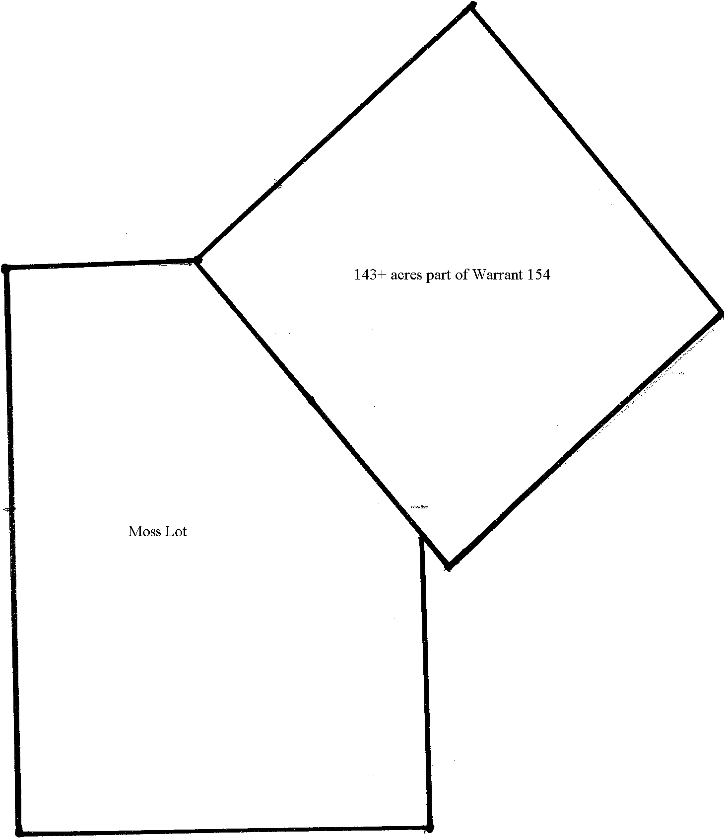
On May 30, 1827, Reuben Daggett conveyed to Rufus Daggett 143 ¼ acres of land in Jackson and Wells Townships. That land was out of Warrant No. 154.24 That Warrant was an oddly shaped warrant. It started at the Northeast corner of Lot 116 where that corner was lacking to make it a rectangular shape. Warrant 154 formed the corridor through which SR 549 ran from Lower Daggett through Wells Township. I have found no record on how Reuben obtained his interest in the 143 ¼ acres. The deed did not specify if the Reuben Daggett in the deed was Sr. or Jr.
On June 2, 1827, Rufus and Hannah Daggett conveyed 131.8 rods (0.82 acres) of the gristmill lands to Jonathan Whittlock.25 The property was not the same size as the former Benjamin Smith one acre lot, but it was in the same area. More will be said about this conveyance later on.
On December 14, 1827, Rufus and Hannah Daggett conveyed 51 ½ acres of the 143 ¼ acres to Joshua G. Spencer.26 That left Rufus with 91 ¾ acres of land out of Warrant 154. The property that was left was partly in Jackson Township and partly in Wells Township.
Rufus was assessed in full for the gristmill in 1828.
On Christmas Day of 1830, Rufus conveyed a ¼ acre lot out of the Moss lands to John G. Hubbell.27 The lot was located on the west side of the road and contained a house upon which Hubbell resided. If you compare the deed description with the description of the Whittlock deed, the Hubbell lot was adjacent to and north of the Whittlock lot, but the Whittlock lot extended behind the Hubbell Lot on its west side possibly across Seeley Creek.
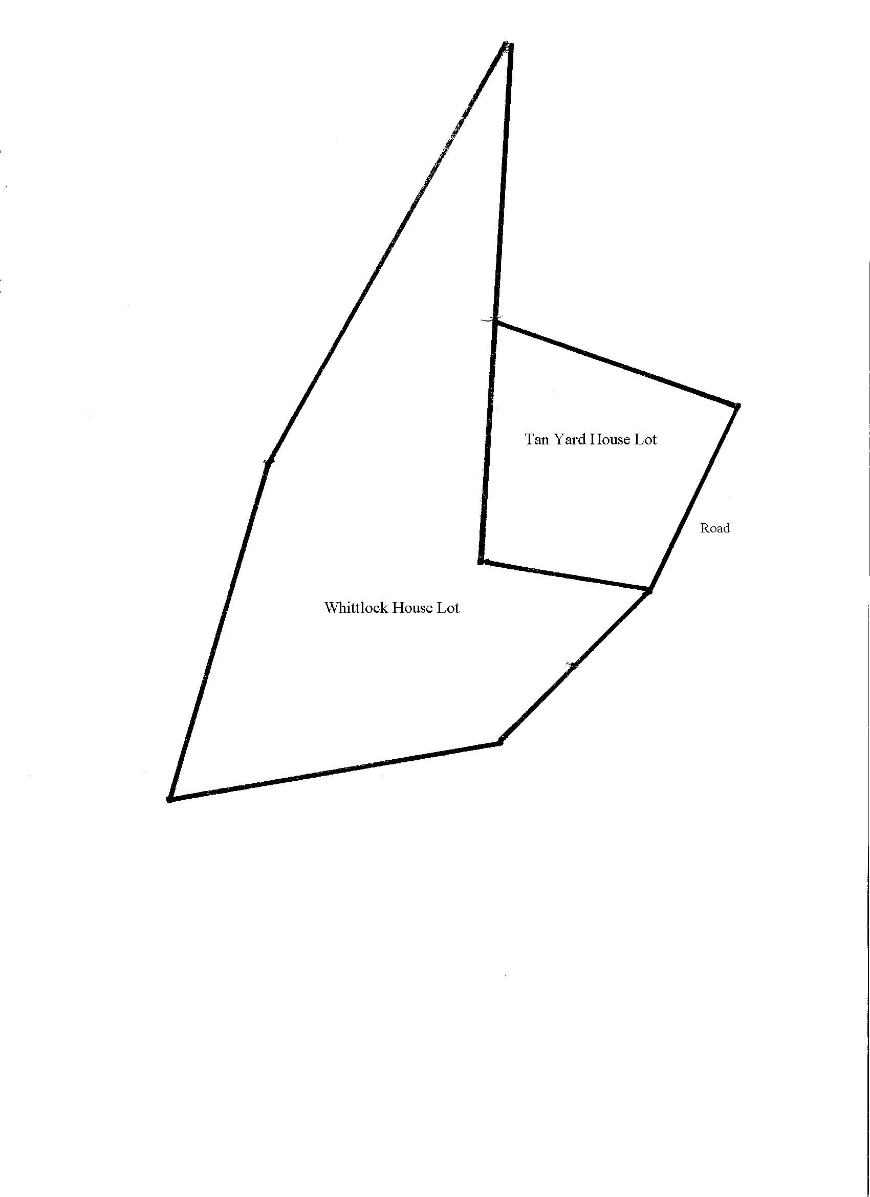
On the same day, Rufus conveyed a second lot out of the Moss lands to John G. Hubbell.28 That second lot contained 2 1/8 acres of land. It was described as containing a tan yard and currying shop constructed by Mr. Hubbell. Mr. Hubbell also had the right to use surplus water from the gristmill for grinding bark and culling and rolling leather only. Rufus reserved the right of free passage of water and the privilege of sinking the race 4 foot below the bed of its present channel. I believe that tan yard was located on the east side of the road between the current Jeffrey Wheeler property and the perpendicular hill that SR 549 now goes through.29 This is the earliest record I have found for the tan yard or tannery. According to the deed, it existed before the date of the deed, but for how long? More will be said about the tannery lot.
Finally, on Christmas Day of 1830, Rufus and Hannah Daggett, for the sum of $2,750.00, conveyed 133 acres and 40 rods to Jeremiah Ayers.30 This tract contained the gristmill and was rectangular in shape being 164 perches (2706 feet) east to west, and 130 perches (2145 feet) north and south. Does this conveyance reflect the assessments to Reuben Daggett, Jr., that began with the 1812 assessment?
The southern boundary of this tract was the southern boundary of the Moss lot previously discussed. The western boundary was part of the western boundary of the Moss lot. As you will recall, the eastern boundary of the Moss Lot was only 118.5 perches long, so this conveyance extended beyond that by 11.5 perches (189.75 feet) into Warrant 154. Therefore, this conveyance was part of the Moss lot and part of Warrant 154.
The conveyance may not have included where the current Kenneth Eighmey house is
located just south of the Eighmey Road (T-789). Does any part of that
house date back to Rufus Daggett or before, and was it where Rufus Daggett lived
at the time?
The deed excepted the two lots sold to Mr. Hubbell.
The 1831 assessment records for the Township reflect the transfer of ownership to Mr. Ayers, and for the first time, show an assessment for a sawmill on the property. Who built the sawmill? How long had it existed before 1831? Was it the sawmill anticipated in the Benjamin Smith deed?
The 1830s saw the beginnings of the great lumber boom in Jackson Township. With an existing water source in place, it seems logical that a sawmill would be built around that time on the gristmill seat. If the sawmill that was assessed in 1831 had existed much earlier, you would think that the Township would have made sure that it was assessed for tax purposes. Perhaps, the recording of the deed resulted in the assessment.
I have been unable to determine the exact location of the sawmill. It may have been built near the gristmill to make use of the mill race and water supply.
Why would Rufus sell the gristmill? Why did he not sell the entire Moss lot? Did he continue to live in Lower Daggett?
Let us pause for a moment and look at Rufus Daggett, or Rufus Daggett, Sr.
Rufus Daggett, Sr., was born on December 3, 1792, in Westmoreland, New Hampshire.31 He was the second of Reuben Daggett, Sr.'s sons to have been named Rufus. The first one died at the age of 4 years. Rufus was the third and youngest son of Reuben and Esther Daggett to reach adulthood.
Rufus Daggett, Sr., is not listed by name in the 1810 census records covering Jackson Township, Wells Township, Westmoreland, New Hampshire, or Oneida County, New York, which is not surprising because he would not have been an adult at that time. There is not a male with his age listed in the S. Daggett or the R. Daggett listings found in the Oneida County census. It is likely that he was living with his father at that time and that he came to the Daggett area with his father in 1807. He would have been around 15 years of age at that time.
On January 8, 1817, he married Hannah Sharp.32 Hannah was from what is now Rutland Township. I have found conflicting information about Hannah. She was either the daughter of Andrew Sharp or Cornelius Sharp. Andrew and Cornelius were either father and son, or brothers.33
Rufus and Hannah had eight children. Their names were William Daggett, Rufus Daggett, Jr., Hannah Daggett, Lucinda Daggett, Cornelius Daggett, Sally Daggett, Laura Daggett, and Miranda Daggett.34
Rufus was active in local Township politics. He was elected to a term as justice of the peace in 1829 and also filled such offices as supervisor, tax collector, and auditor.35
On June 1, 1810, Andrew Sharp purchased 200 acres of land in Tioga Township that would later be part of Rutland Township.36 The property was just east of what would be the eastern boundary of Roseville Borough.
On February 3, 1815, Andrew conveyed 120 acres of the 200 acres to David Paine of Athens, Pennsylvania.37 The conveyance included a mill seat and mill privileges. It is not clear whether the mill was a gristmill or a sawmill, or whether or not Andrew Sharp had built and/or operated the mill.
On November 21, 1820, Andrew and Abigail Sharp gave a deed for the entire 200 acres to David Paine.38
On November 24, 1820, David Paine conveyed a 30-acre tract of land to Andrew Sharp.39 The 30 acres was where the Sharps resided. I did not check to see if the 30 acres was part of the 200 acres.
On October 21, 1831, John Benson conveyed to Rufus Daggett and Lyman Gibson certain water
privileges on Mr. Benson's lands to be used in connection with lands of Rufus Daggett in Rutland Township.40
On January 20, 1835, Andrew Sharp conveyed his 30 acres to Rufus Daggett just 11 days before Rufus died.41
The Estate of Rufus Daggett claimed Rufus had an interest in 233 1/3 acres of land and a gristmill in Rutland.42 His administrators petitioned the court to sell 200 acres in Rutland. The petition stated that Rufus had a ½ interest in the 200 acres and a gristmill thereon. Rufus had intended to sell his interest in the 200 acres before he died in order to raise money for repairs to the gristmill in Lower Daggett. The repairs were already underway on the Lower Daggett gristmill, and no money was available to pay for the repairs. Listed among his debts was a bill for $500.00 owed to Allen and Lyman Gibson. They were millwrights and may have been doing the repairs on the Lower Daggett mill.43
One of the histories published about Tioga County referred to a gristmill in Jackson Township that was erected by Reuben Daggett, Jr., and Seth Daggett in 1836. The millwright work was supposedly done by Allen S. Gibson and Lyman Gibson.44 Reuben Daggett, Jr., was long gone by that time, Seth was an administrator of the Estate of Rufus Daggett, and I cannot find any record of the supposed new gristmill. Perhaps, that account was referring to the repair work being done on the Lower Daggett mill after the death of Rufus Daggett. It may be that the old mill was completely or substantially replaced in 1836.
Rufus Daggett's interest in the gristmill and 200 acres in Rutland Township was sold, but there are no deed records to verify it.
On June 8, 1836, and on September 29, 1836, David Paine conveyed two lots totaling 289 acres of land to Allen Gibson and Lyman Gibson.45 That conveyance included the 200 acres from Sharp to Paine and the gristmill. It was said that Lyman, Allen, and William Gibson succeeded Rufus Daggett and Lyman Gibson as owners of the gristmill.46
Rufus and/or Lyman Gibson must have been buying the 200 acres from David Paine before Rufus died. After he died, Allen Gibson and/or Lyman Gibson purchased the interest of Rufus Daggett and eventually paid off Mr. Paine. Perhaps the Gibsons worked out a deal to repair the Daggett gristmill in return for the Rutland gristmill.
The 289 acres and the gristmill passed through many hands until May 6, 1870, when George W. and Susan Van Allen split off the gristmill property into a 20+ acre tract of land and conveyed it to Orrin and Burton Schrader.47 The gristmill became known as the Schrader Mill.
There is a picture of the gristmill that was taken in the 1900s.48 Today, the gristmill property is owned by Martin L. and Rose A. Kasper.49 The property contains what I have always heard called the Roseville Pond. That body of water must have been a mill pond for the gristmill.
So why did Rufus sell the gristmill in Lower Daggett to Mr. Ayers? Had he simply lost interest in that mill, or did he need the money for the gristmill in Rutland?
Did Rufus ever move to the Rutland area? Did he continue to live in Lower Daggett probably in the area where Kenneth Eighmey know lives?50
By deed dated November 5, 1832, Jeremiah and Lucinda Ayers, for the sum of $1,600.00, reconveyed the property, gristmill, and sawmill back to Rufus Daggett.51 That deed lists several conveyances made out of the property by Rufus and Jeremiah. Those conveyances will be discussed later on.
The deed stated that Rufus held a mortgage on the property.
The deed also stated that Jeremiah was a resident of Jackson Township, but the deed was acknowledged in Tompkins County, New York. The tax assessment for Jeremiah was marked “ran away.”
Are the facts surrounding the conveyance an indication the gristmill was not
profitable?
From November 5, 1832, until his death on January 31, 1835, at the age of 42
years, Rufus Daggett, Sr., was the record owner of both the gristmill and the
sawmill. Rufus was survived by his wife, Hannah, who was about 38 years old at
the time of his death, and his children, William, Hannah, Rufus, Jr., Lucinda,
Cornelius, Sally, Laura, and Miranda.52
Rufus was buried in the Daggett family cemetery in Lower Daggett.
Rufus died January 31, 1835, at the age of 42 years, Reuben Daggett, Sr., died February 8, 1835, at the age of 79 years, Jonathan Whittlock died February 19, 1835, at between the age of 45 to 55, and Sally Ann Roberts, wife of Dr. H.B. Roberts, died January 5, 1835, at the age of 26 years.53 They all lived in the Lower Daggett area. Something must have been going on. Was there an epidemic in Lower Daggett?
Reuben's grave marker has two dates of death on it. One is his and one is that of his son Rufus. Was there a great deal of confusion going on at the time?
Rufus died intestate (without a will) and his brother Seth Daggett and his widow, Hannah, were appointed as administrators.54 His Estate file has either been misfiled or taken from the courthouse. There are records in the Orphans' Court that show what happened.
We have already discussed the 233 1/3 acres of land in Rutland. The Estate sold off the interest in the 200 acres and kept the 33 1/3 acres.
The Estate claimed 450 acres of land in Jackson Township.55 Of the 450 acres, 150 were listed as being improved. I cannot determine the location of all of the 450 acres until they are split up at a later time.
The land contained 3 frame dwellings, 2 frame barns, 1 gristmill, and other outbuildings and improvements. I have been able to identify at least 6 structures in Lower Daggett at that time that may have been dwellings. They were the Whittlock house, the tan yard house, the Roberts store, the E.D. Roberts house, the Reuben Daggett, Sr., house, and the Rufus Daggett house. The first five will be discussed in Part II hereof.
Rufus had no interest in the Whittlock house, the tan yard house, the Roberts store or the E.D. Roberts house.
Reuben, Sr., died 8 days after Rufus died. No Estate was filed for Reuben, Sr. It is possible that the Rufus Daggett Estate claimed ownership of the Reuben Sr., house, but I have found no direct evidence that it was one of those 3 dwellings.
Although I have no direct evidence of it, I am guessing the current Kenneth Eighmey house was the location of the last residence of Rufus Daggett.
It is also possible that the original Reuben Daggett, Sr., homestead house was still in existence.
There is just not enough evidence to establish where those 3 frame dwellings were located.
The 1835 assessment was placed in the name of Hannah Daggett as a result of the death of Rufus.
The 1837 and 1838 assessment records assess Hannah Daggett for the land upon
which the gristmill and sawmill were located and assess Alexander Bentley for
the mills and the land. If those assessments were correct, the tax people were
taking a double dip. For those two years, Mr. Bentley must have had an
interest in the mills. There is nothing in the courthouse records, other than
the assessment records, to indicate that he did. I have no idea who Mr.
Bentley was.
In 1839 the assessment for the land and the mills is solely in Hannah Daggett’s
name. The assessment for 1841 lists William Daggett as the owner with Hannah as
the owner the following year.
In 1846 the assessment records list the sawmill as “rotten” and permanently remove it from the assessment records.
William Daggett was the oldest of the eight children of Rufus and Hannah
Daggett. He was born December 26, 1817, and was 17 years old when his father
died.56
On February 21, 1849, he filed a petition with the Orphans' Court of Tioga
County requesting the Court to partition or divide up 33 1/3 acres of land in
Rutland Township and 450 acres of land in Jackson Township claimed by his father
at his death.57
The Tioga
County Sheriff impaneled a group of local landowners to assess the properties.
Upon their recommendation, the 450 acres in Jackson Township were divided into
five tracts.
Before we discuss the five tracts, let us look at the conveyances that were made by Rufus Daggett, Sr., and Jeremiah Ayers out of the Moss lot.
DCW May 2019
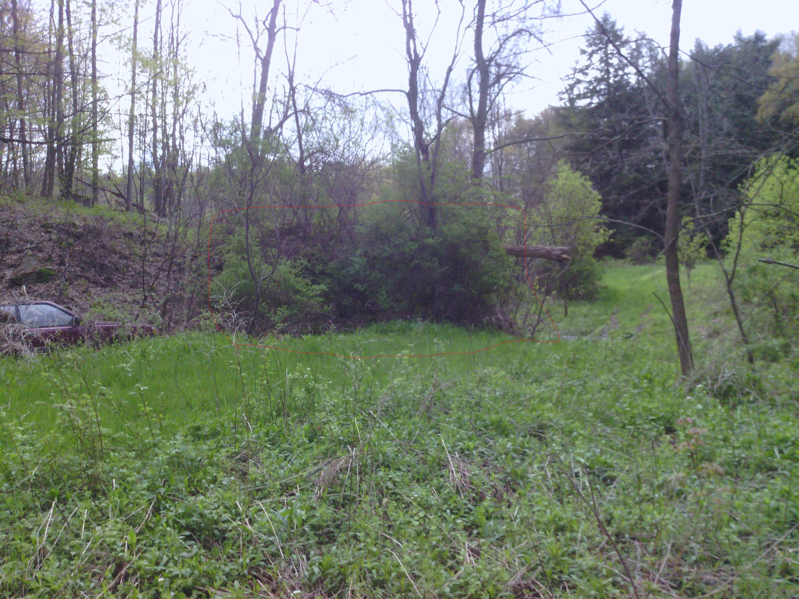
This picture looks south on the east side of Seeley Creek. The remains of the old mill dam are to the right of the old car in this picture. The mill pond would have been on the other side of this section of the dam. The old road was located above the old car.

1a
This picture was taken on the west side of Seeley Creek looking north. The mill pond would have been in front of these remains of the old dam.
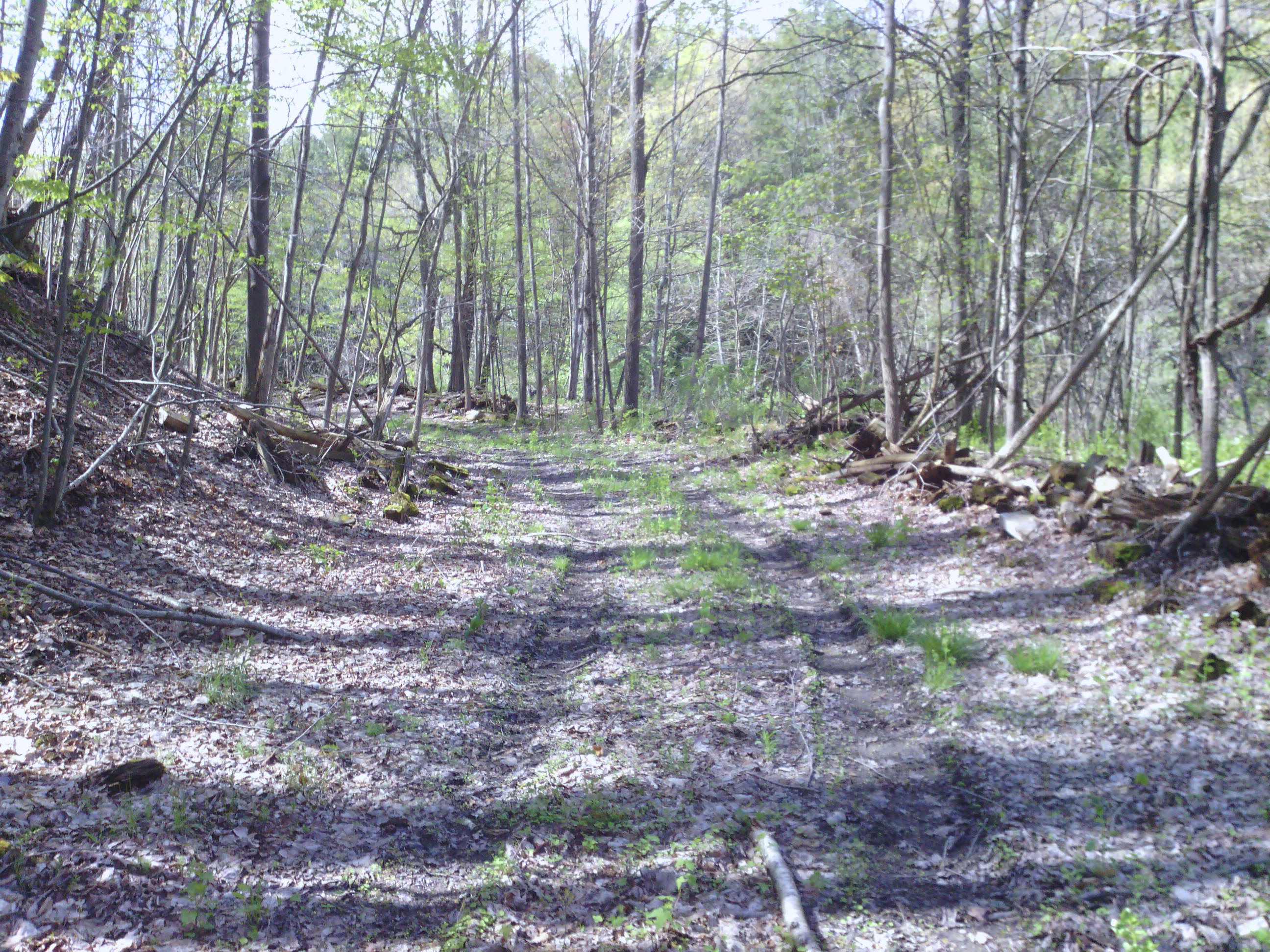
This picture of the old road looks south around Eighmey's Bend.
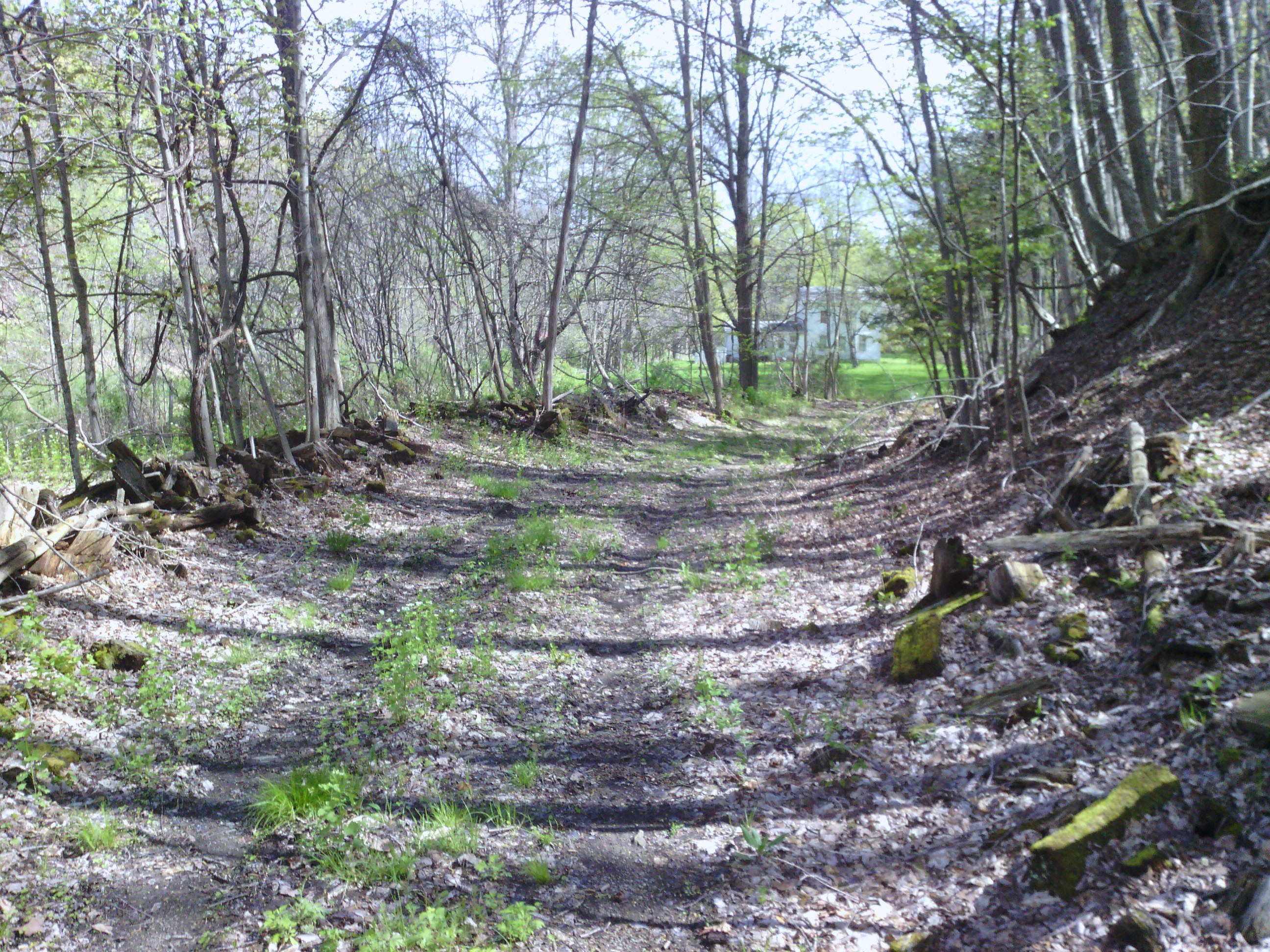
This picture of the old road looks north along Eighmey's Bend. The house is the current Curtis Voorhees house.
Lot 116
Warrant 1410
This is a larger scale drawing of the B. Smith one acre lot. The upper half right boundary may be where the current roadway is. The bottom half right boundary may be where the old roadway went around Eighmey's Bend. The shop may have been where the Curt Voorhees house is today.
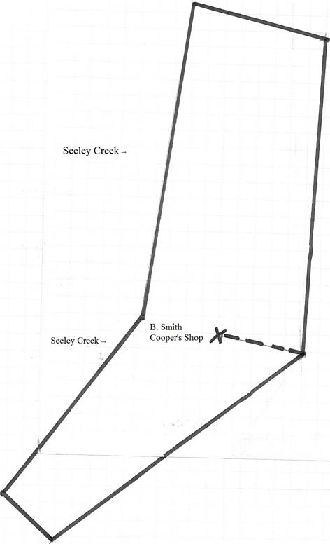 |
The B. Smith Lot and the Whittlock House and Lot were in the same area, but it is difficult to picture how they fit together. The line running northerly between the Whittlock Lot and the tan yard House and Lot may have been Seeley Creek.
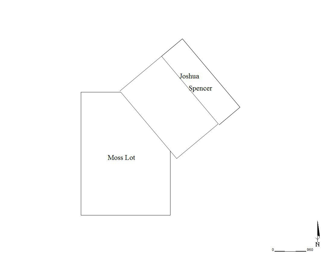
The lot conveyed to Spencer is now
assessed in Wells Township as part of the Wayne Brown property and contains
his house and garage combo. See Bradford County Tax Parcel
57/014.00/003.
1 SR 549 was known as Route 308 at one time. Substantial changes were made to the road including a bypass around Mosherville and moving the road from around the Big Elm. State Highway maps of the project are on file in the Register and Recorder's Office at the courthouse in Wellsboro. I was about three years old at the time. Sadly, the only thing I can remember of the old road is how you traveled on a curve around a hill to the Judson Hill Road to reach Mosherville. The curve is still there. The Gas Company, at one time, had a metal building on the curve. It would make an interesting article comparing the old road with the changes that were made in 1957. Much history was lost.
2 See attachment 1a.
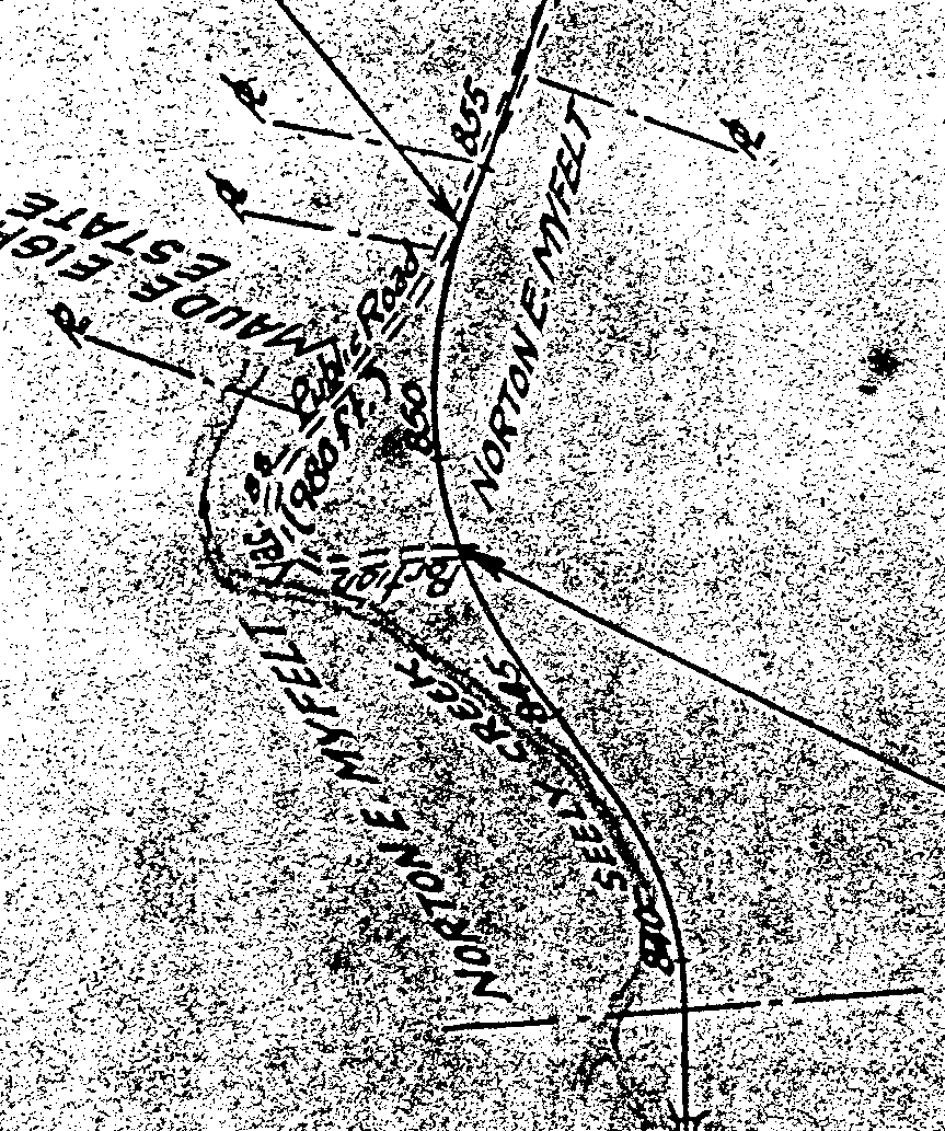
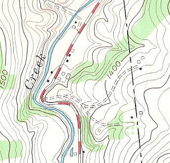
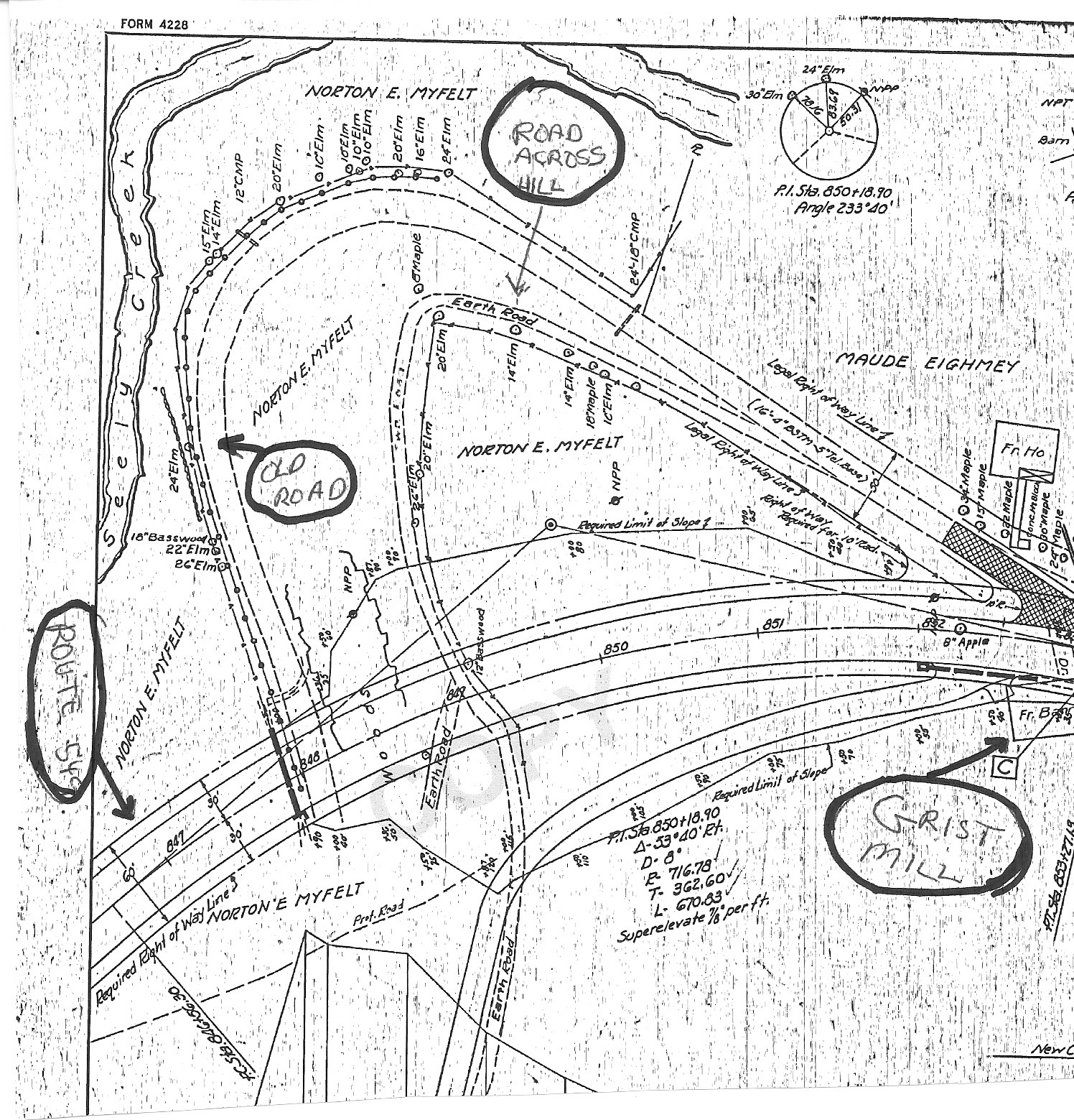
3 See attachments 2a, 3a, and 4a. 2a is a map filed in Tioga County Map File 2713. It has been enlarged. It shows Eighmey's Bend and the path of the current road that was cut through the hill. 3a is a copy of a section of a topographical map depicting the road around Eighmey's Bend and the road that went across the top where the cut was made. One of the buildings on the right of the road just north of the Bend would have been the old gristmill. United States Department of Interior Geological Survey. Millerton Quadrangle Pennsylvania 7.5 Minute Series (Topographic). Map. U.S. Geological Survey (1954). 4a is a copy of the State Highway Map depicting Eighmey's Bend and the new road. I have added to that map in circles the Gristmill, Route 549, the road across the hill, and the west side of the old road. Tioga County Register and Recorder's Office Instrument 195701002 page 12. (partial and enlarged).
4 See attachments 5a and 6a.
5 Tioga County Deed Book 1 at page 172.
6 Donna Bingham Munger, Pennsylvania Land Records A History and Guide for (Lanham, Md: SR Books, 2000), pg 234.
7 Munger, 234 and P. Nicholson Wood, Ladner on Conveyancing in Pennsylvania with Forms 3rd Edition (Philadelphia: George T. Bisel Company, 1961), pg 310 note 98.
8 Tioga County Mortgage Book 1 at page 143.
9 8008 Route 549. Tax Parcel 17/04.00/021.
1 0 Tax Parcel 17/4.00/074 and 17/4.00/055. See attachment 5a.
1 1 Now assessed in Bradford County.
1 2 The missing corner is part of Warrant 154.
1 3 R.C. Brown & Co., ed., History of Tioga County Pennsylvania (Harrisburg: Press of the Harrisburg Publishing, 1897), 67.
1 4 Brown 65. Were they the oxen that brought the Daggetts here according to the old stories?
1 5 Brown 67.
1 6 Tioga County Deed Book 3 at page 335.
1 7 Tioga County Deed Book 3 at page 357. See attachment 7a.
1 8 The biggest mystery I have been unable to solve is where exactly did Reuben Daggett, Sr., settle, and did he come here with a land claim, or was he a squatter? When I first started to research the gristmill, I heard stories about a log cabin and grave sites on the hill east of the gristmill site. I thought that might somehow relate to Mr. Moss. There is no physical evidence of a log cabin having been there, but I did find a fieldstone sticking upright in the ground. Nothing was carved onto it. Was that a grave site? I doubt it, but if it was, there is no evidence to tie it to any specific individual.
1 9 Samuel Bradlee Doggett, A History of the Doggett-Daggett Family, (Boston: Press of Rockwell and Churchill, 1894), 164.
2 0 Doggett 164.
2 3 There are so many unrecorded conveyances in Lower Daggett I sometimes think there must be something in the water. Did the distance from Lower Daggett to Wellsboro play a part in not recording deeds?
2 4 Tioga County Deed Book 7 at page 333. See attachments 6a and 8a. This is an important but very frustrating deed. The deed did not specify if the grantor was Reuben, Sr., or Jr. It did state that Reuben was from Jackson Township. If that grantor was Reuben, Sr., it is the only evidence I have found that Reuben, Sr., may have owned land in the area he settled. It also creates the possibility that Reuben, Sr., could have originally settled in Bradford County. Reuben, Jr., had moved out of the area by the time of that deed. The deed did not give the marital status of Reuben. Reuben, Sr., married for the 3rd time the day after the date of that deed. Doggett 132. Reuben, Sr., appears in the 1830 Census for Wells Township. That deed could have answered many questions about the early history of the Daggett family.
2 5 Tioga County Deed Book 11 at page 401. See attachment 9a.
2 6 Tioga County Deed Book 7 at page 433. See attachment 10a.
2 7 Tioga County Deed Book 9 at page 117. See attachment 9a.
2 8 Tioga County Deed Book 9 at page 118. See attachment 11a.
2 9 See attachment 11a. The tan yard property bounded the gristmill site on the north and east, and it appears to extend to the perpendicular hill. See segment AB of attachment 11a. It was said that the gristmill was oriented due north and south. Segment AB would tend to confirm that. There is onsite evidence that the tail of the mill race may have flowed around the base of the hill on the east side of the Moss property and followed that hill to the area of the current Lorenzo Road (T-792 ) where it emptied into a small tributary of Seeley Creek. Were segments AF and FE of attachment 11a the base of that hill? Again, it would be nice to try and have the old lots surveyed to actually see where they were in relation to the lay of the land today. Segment CD was the road and was 14 rods long (231 feet). The eastern boundary of the tan yard house was along that same road segment but was only 6 rods long (99 feet). Today, the Cheryl Ostrander et al tenant house occupies the area of the tan yard house. Does any part of that house date back to the tan yard house? The former tan yard today contains the barns and mobile home rental property of the Cheryl Ostrander et al property on the east side of SR 549. Again, the tan yard lot and house would make an interesting subject for a survey. For Cheryl Ostrander et al assessment see Tax Parcel 17/04.00/074.
3 0 Tioga County Deed Book 9 at page 79. Why was so much land conveyed? Could it be that the location of the tail of the mill race had something to do with it?
3 1 Doggett 165.
3 2 Doggett 166.
3 3 W.W. Munsell & Co., ed., 1804 to 1883 History of Tioga County, Pennsylvania, (New York: W.W. Munsell & Co. 1883) 335.
3 4 Doggett 166. You will sometimes see Cornelius spelled Cronelius. I believe that to be an error, maybe even a typo. His name on his grave marker in the Mosherville Cemetery is C.C. Daggett. No help there.
3 5 See the section of my history on election returns.
3 6 Tioga County Deed Book 3 at page 288.
3 7 See Note 36. Andrew signed the deed using his mark. I believe David Paine was the David Paine associated with the Susquehanna Company.
3 8 Tioga County Deed Book 8 at page 152.
3 9 Tioga County Deed Book 5 at page 65.
4 0 Tioga County Deed Book 9 at page 374.
4 1 Tioga County Deed Book 13 at page 223.
4 2 Orphans' Court Docket A at page 16, No 1 February Term 1836.
4 3 The Gazette Company, An Outline History of Tioga and Bradford Counties in Pennsylvania, Chemung, Steuben, Tioga, Tompkins and Schuyler in New York by Townships, Villages, Boro's and Cities (Elmira, New York: The Gazette Company, 1885), 36.
4 4 See note 43.
4 5 Tioga County Deed Book 12 at pages 508 and 510.
4 6 Brown 553.
4 7 Tioga County Deed Book 45 at page 543.
4 8 Gale Largey, ed., Life in Roseville: A Socio-Historical Portrait (Mansfield, Pennsylvania: Bailey Printing Company, 1973). Photo is on the second page of photos after page 46.
4 9 67 Pond Road. Tax Parcel 31/4.00/021.
5 0 The house located south of the intersection of the Eighmey Road (T-789) and SR 549. Part of Tax Parcel 17/04.00/059.
5 1 Tioga County Deed Book 10 at page 425.
5 2 Doggett 165-166.
5 3 Dates of death and ages for Reuben and Rufus see Doggett 132, 165-166, for Jonathan Whittlock see Estate info to follow and 1830 census, and for Sally Ann Roberts from her grave marker in the old Daggett Cemetery in the village of Daggett.
5 4 Tioga County Register's Docket A at page 49.
5 5 Orphans' Court Docket A at page 170, No. 1 February Term 1849.
5 6 Doggett 166.
5 7 See note 55.